Planning a road event such as a marathon, cycling event, parade, motorsport street circuit or torch relay is a challenging operation which requires multi-agency collaboration. With a tendency to cover a wide geographical area, there can be knock-on effects far beyond the event itself.
Consider the challenges faced by the organisers of the Tokyo 2020 Olympics torch relay. The torch will run for a total of 121 days covering all of Japan’s 47 prefectures. The scale of an event like this can require hundreds or even thousands of maps and plans, to assess risks, plan logistics, manage crowds and ensure safety. Producing these visuals takes a great deal of time but are essential to coordinate and communicate effectively across multiple agencies.
Coronavirus restrictions have presented even more of a challenge. Organisers have had to put additional safety measures in place to protect spectators, torch bearers, management staff and local residents. According to the official Tokyo 2020 website 98% of Japan’s population will be within an hour’s journey from the torch relay.
When planning road events, there are many stakeholders to work with, each with different concerns and levels of authority. Potential disruption to the public needs to be quickly identified and communicated in a clear and unified way.
The Iventis platform was designed to bring organisers, stakeholders and even the public together in one common visual environment. The following guide explains how.
A Holistic View
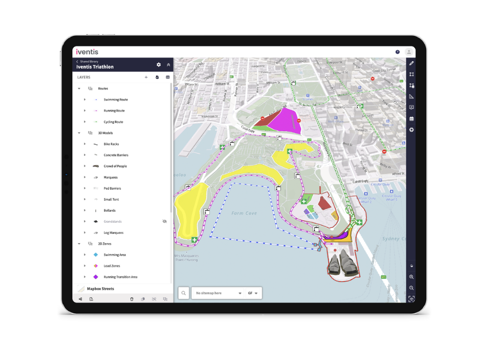
Iventis’ visual event planning platform can display any map data and comes preloaded with both map and satellite imagery available globally. Additional data sources such as hyper local mapping data, aerial imagery or topography can also be included to ensure you have the most up-to-date geographical dataset as a context for planning. For example, in the UK we integrate with the OS Data Hub to give organisers access to the most detailed, country-wide mapping data available.
The ability to plan a road event at every scale in one place is the best way to ensure seamless operational plans are always available across the whole team. Alongside the world map, Iventis can be easily integrated with CAD drawings and 3D models of venues and facilities. This level of detail allows users to meticulously plan every detail of their services and even visualise the look and feel of the event. The entire event can be planned, from the detail of the start/finish areas to the length of the route.
Having this information stored in one place makes planning simpler, more co-ordinated and reduces communication overheads. Road events can be incredibly complex, and changes have to be shared quickly among stakeholders. The Iventis platform can be accessed by everyone involved, so they can act on any changes as soon as possible. This reduces uncertainty, cuts down on meetings and saves time.
Flexible Planning
The Iventis platform is designed to enable every aspect of a road event to be planned. Workers are able to collaborate remotely without the need to travel to site.
Different functional areas, covering different operational aspects such as transport/traffic, crowd management and workforce, can organise their plans into different plans and folders. They are then able to combine their layers with wider plans to identify conflicts, risks and opportunities. The plan design is completely customisable, so complex plans can be clearly communicated. For a road event, this could mean combining sport related layers such as the routes, distance markers and medical points to help plan associated traffic management and road closures. This data can be exported in multiple file formats for further analysis.
Routes can be generated automatically then planned down to the smallest detail.
Other operational aspects of road events which can be planned include:
- Traffic management measures
- Pedestrian and vehicle barriers
- Staffing
- Health & safety
- Press & broadcasting positions
Asset Planning
Road events require a large number of assets and resources to be deployed across a wide area. This incurs significant costs and can be difficult to procure in large quantities. As a result it is important to know the quantities of assets and resources required along a route well ahead of time to prevent wasted expenditure.
Once a route has been plotted in Iventis, assets such as barriers, scrim and traffic cones can then be calculated. These features can be added to the map along with scaled 3D models of the product so that quantities can be calculated and visualised.
These plans can also be viewed and exported in a tabular format, similar to an excel spreadsheet, associated with item costs and submitted for procurement.
Crowd Control
One of the greatest challenges of planning a road event comes from the general public. There are often significant sections of the route where attendance cannot be fully controlled.
Public events are great for community engagement, but free-to-view events can make operational and safety planning more difficult. The Iventis software has a wide variety of tools to help organisers plan and visualise viewing areas.
As an example, green spaces along the route of a road event will attract a large number of spectators. Using 3D imagery, calculating how many people can safely occupy a space is made much easier. Iventis has built in crowd capacity measuring tools to quickly assess a space under different crowding densities.
Iventis’ web-based platform ensures information and plans can be shared with those who need them, both digitally and in printed formats. Once designated spectator areas have been planned along the route, this information can be made available to the public.
As the plans develop, more stakeholder groups can be invited to view the data. Local police, fire and rescue services and local authorities can access planning data from the organisers so they can implement their own plans and processes.
Timing
Timing is a crucial component when planning a road event. Authorities will need plans submitted to them as soon as possible, so they can make the right preparations such as traffic regulation orders (TROs).
It’s important to keep the impact of the event to an absolute minimum. Road closures are usually necessary, the welfare of local residents has to be taken into consideration, and any changes to the plan have to be quickly communicated and coordinated.
With Iventis, plans can be developed not only geographically but also on a minute-by-minute basis. This can be visualised via a timeline to clearly communicate the sequence of operations.
Using Iventis to Plan a Road Event
Road events of any scale can be planned using the Iventis platform, making it well-suited for any major or local event. From mapping the route to ensuring staff have the most up-to-date plans, Iventis has the tools available to cover every scenario.
It takes a significant amount of time and expenditure to plan a road event, and the better coordinated teams are, the more money and time can be saved. Thorough planning also improves the quality of the event, giving spectators a more enjoyable experience.
Public road events create unique opportunities for mass participation and engagement in sport. Regardless of the operational challenges, Iventis can greatly assist in the planning and co-ordination of a successful event.
For more information on how Iventis can help with road event planning, drop us a line.