
We spoke to Georgina Horstman, Events & Marketing Coordinator for Lardner Park and host of one of Australia’s biggest agricultural shows, Farmworld, to find out what implementing Iventis means for them.
We signed with Iventis to drive the full digitisation of our 300-acre Lardner Park site, with particular focus on detailed planning overlays for the 110-acre main Event Space.
Before Iventis, we were relying on Adobe Illustrator to manually create event maps. This approach was time-consuming, prone to version-control issues, and made it difficult to maintain accurate, up-to-date information across a large and complex rural venue that hosts everything from Farm World and major music festivals to weddings and community events.
Our key objectives were to:
Iventis now gives us one integrated system to efficiently create precise event layouts, manage the full property digitally, and streamline planning — delivering greater accuracy, efficiency, and peace of mind for every event we host
 (Fig 1 – Initial space allocation planning)
Can you tell us about some of the projects, events, or initiatives you have delivered using Iventis?
A great example is the planning and delivery of Farm World, Victoria’s premier agricultural field days at Lardner Park.
Iventis has enabled us to fully digitise the layout of the 110-acre main Event Space within our 300-acre venue. We use the platform to accurately mark out exhibitor sites, sponsorship activations, infrastructure, and all other event elements, while maintaining a single, central digital source of truth for bookings and site information. This has replaced our old process of printed maps and manual highlighting, which was time-consuming and prone to version issues.
We’ve taken this a step further by integrating Iventis with on-ground operations. We invested in a Topcon GPS Rover and now export KML data directly from Iventis into the rover. This allows our team to accurately and efficiently mark out all Farm World sites in the field.
The results have been impressive: a process that previously took up to five days is now completed in just two and a half days — a 50% time saving. We expect this to improve even further as the team gains more experience with the technology.
Iventis is now supporting our broader event program, including music festivals, rodeos, weddings, and community initiatives. It has become a cornerstone of our digitisation efforts at Lardner Park, delivering major gains in accuracy, efficiency, and collaboration.
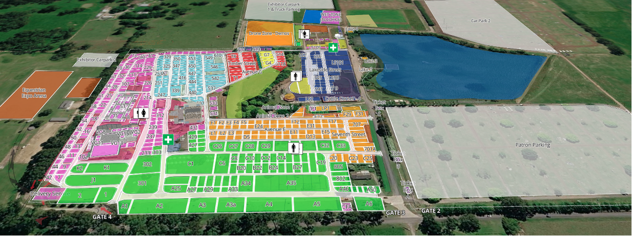 (Fig 2 – Development of a detailed show plan with exhibitor areas and services)
What benefits has Iventis brought to your organisation and key stakeholders?
Iventis has delivered significant benefits across our entire 300-acre Lardner Park site, with particular value in the detailed digitisation and planning overlays for the 110-acre main Event Space. We now have a fully scaled digital – Lardner Park Master Plan, highlighting key agricultural trials across the site as well as greater planning capacity for the 110-acre main event space.
One of the standout advantages is the ability to accurately map and centrally manage all utility services — including power, fibre, CCTV system (40 cameras across the property), water, drainage, effluent and communications infrastructure — across the full property.
Having this critical information recorded in a single, always-up-to-date digital system means our staff, contractors, and external teams can quickly access precise service locations whenever needed. This has greatly enhanced safety across the site by reducing the risk of accidents, damage, or incidents during event setup and groundworks. Especially valued by temporary marquee providers driving 900mm pegs into the ground and avoiding safety concerns.
Additionally, the platform’s simple sharing functionality via a time-limited secure link allows us to provide venue hirers, contractors, sponsors, and other stakeholders with direct access to the latest site plans and overlays via a secure link. This has dramatically reduced the time previously spent emailing updated maps or handling version queries, while significantly improving communication and collaboration.
Overall, Iventis has streamlined our operations, enhanced safety, reduced administrative workload, and improved the experience for everyone involved — from our internal team and Board through to external partners and event organisers. It has become a vital tool in our ongoing digitisation journey at Lardner Park.
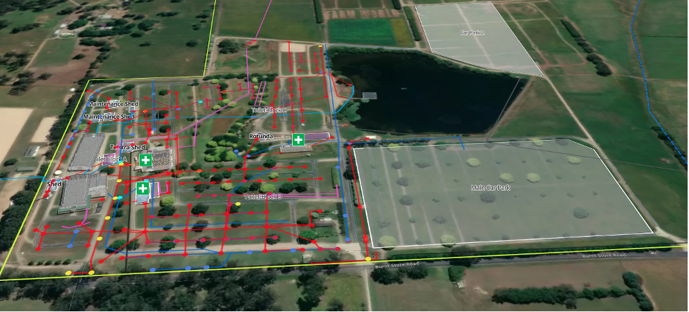 (Fig 3 – Map of essential facilities such as water, gas and electricity to share with stakeholders)
Iventis has fundamentally transformed our planning and operational processes at Lardner Park as part of our broader digitisation of the full 300-ac
re site, including detailed planning overlays for the 110-acre main Event Space.
A strong example is:
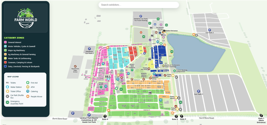
Farm World. We used Iventis to create and publish a live, public-facing interactive map of the entire event site. This map now integrates seamlessly with our new Farm World App, providing exhibitors and patrons with an intuitive, mobile-friendly way to navigate the large rural venue. Users can view their real-time location on the map directly within the app, making wayfinding effortless across the expansive grounds.
This innovation has been extremely well received and has delivered tangible results:
By replacing static printed maps with dynamic, real-time digital tools and seamless app integration, Iventis has modernised our entire approach to event planning and delivery. It has enhanced accuracy, efficiency, safety, and collaboration across all events — from Farm World to music festivals, rodeos, weddings, and community initiatives — and continues to drive ongoing improvements at Lardner Park.
One of the most valuable features has been the ability to share a live link to our comprehensive utilities map.
As part of our digitisation of the full 300-acre Lardner Park site (including detailed planning overlays for the 110-acre main Event Space), we now maintain an accurate, central record of all utility services — power, water, drainage, communications, and more.
The simple sharing functionality allows us to instantly provide venue hirers, contractors, sponsors, and other stakeholders with secure, real-time access to this information. This has delivered major benefits:
This workflow has become a standard part of our operations. It has proven especially valuable for large-scale events like Farm World and A3 Festival, as well as numerous venue hires, expos, and infrastructure projects. It’s a simple but powerful tool that continues to save time and strengthen collaboration across our team, contractors, and external partners.
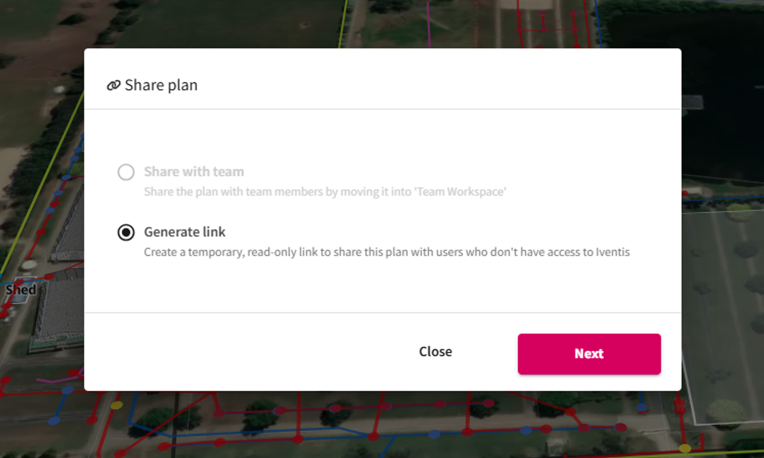 (Fig 5 – Screenshot of Iventis’s view-only link generator)
We see Iventis becoming even more deeply embedded in our operations as we continue the full digitisation of our 300-acre Lardner Park site, including detailed planning overlays for the 110-acre main Event Space.
In the near term, we plan to expand our use of the platform by creating precise, to-scale layouts for the 1000-seat Event Centre (including the proposed new bar, Coolroom, break-out/storage room, and balcony extension) and other key venue spaces. This will allow us to share interactive, professional digital layouts with clients, hirers, and stakeholders early in the booking process.
By giving them a clear, accurate visualisation of how spaces can be configured for weddings, conferences, exhibitions, music events, and more, we expect to:
Longer-term, we’re excited to explore further integration opportunities with our on-the-ground tools (such as the Topcon GPS Rover), additional public-facing maps, and more advanced layering for multi-day festivals and complex activations. Iventis is already a key enabler of our modernisation journey, and we look forward to leveraging it to support Lardner Park’s growth as a premier regional event destination.
 (Fig 6 – Screenshot of 3D building models produced by Iventis)
“Birmingham 2022 is the largest event to be held in the UK since London 2012. That means it is an incredibly complex operation for us to manage. Iventis allows us to knit all of those requirements together in a single platform. It’s absolutely fantastic and so useful across the supply chain for everybody to have access across all of the different venues and fantastic from an efficiency and commercial value perspective”

“The Iventis mapping software has been instrumental with plotting, measuring and storing the relay route on a secure platform. It allows relay planners to use the mapping software as a development tool, creating and amending the routes. Additionally, it allows for multiple user groups, with various access rights, to view or edit plans and see real-time route amendments. Plans can be shared via a link or exported in KML and PDFs files.”