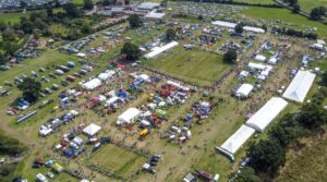
With a legacy lasting over a century, hosting hundreds of trade stands and welcoming around 10,000 visitors each year, the annual Nantwich Show holds a strong reputation as one of the country’s top agricultural events. Having recently relocated away from its former location, the show’s organisers needed a solution that would help them deliver the high quality that visitors expect, on a brand-new, unfamiliar ground.
Delivering an esteemed event in a new location poses significant challenges, and the organising body, the Nantwich Agricultural Society, needed a tool that was easy to grasp, provided support when needed, and helped them to navigate the new land.
Liz Parkin, Show Manager, had an events background but was not well versed in geospatial tools. Because of this, she knew that she needed a solution that could be picked up easily, without the need to spend time learning the intricacies of an overly complex platform.
The show recently moved from its previous location, Dorfield Park, where it had taken place for more than 70 years. Organisers knew their previous location inside out, and the new Nantwich Showground meant starting from scratch when it came to spatial planning.
As a small, busy team without a geospatial specialism, it was crucial that Liz and her colleagues were able to find quick, efficient support when they needed it. A UK-based team and direct contact were therefore important when deciding on a software provider.
Although the show itself is not new, the location change offered the opportunity for Liz to reframe the planning process in a more efficient, digital fashion. The Iventis Planner streamlined planning without causing unnecessary friction due to platform complexity.
The Iventis Planner was built to make geospatial tools more accessible across the events industry, and this approach made it possible for Liz to work confidently and independently throughout the planning process.
With a variety of map bases to choose from, as well as toggles for terrain height and analysis tools like capacity calculators, the Iventis Planner was full of handy features to help organisers get to grips with their new location.
Iventis is proud of its personal, customer-centric approach – and it made a big difference for Liz and the team at the Nantwich Agricultural Society. Our team were on hand to answer any questions and help Liz through any tricky spots during the planning process.
“I needed a solution that could help me visualise the new site and our event’s layout, providing accuracy and an easy-to-use system. It makes it so much easier to plan the site and test new layouts on Iventis, where you can move trade stands around to find the best fit.”
Liz Parkin, Show Manager, Nantwich Show.
After relocating, the esteemed Nantwich Show faced starting from scratch when it came to its geospatial planning procedures. This provided the opportunity to digitise the process with an accessible tool that could streamline operations.
With Iventis, the Nantwich Show significantly improved its planning and prepared for the successful delivery of this legacy show in a new location.
To find out more about how Iventis can streamline your event planning, book a demo with one of our experts today.
"Iventis helped us to provide a solution-led, end to end service for organisers of The Game Fair from CAD drawings and live operational planning to a visual sales tool that helped mark out the site on the ground."

“The Iventis mapping software has been instrumental with plotting, measuring and storing the relay route on a secure platform. It allows relay planners to use the mapping software as a development tool, creating and amending the routes. Additionally, it allows for multiple user groups, with various access rights, to view or edit plans and see real-time route amendments. Plans can be shared via a link or exported in KML and PDFs files.”